Posts

Showing posts from 2011

Greystone Bluff via Cinder Hill

Image
16-23 November 1996 Problems with the minibus meant we had to make last minute arrangements for Sue and Sandra  to drive us to Scotts Peak.  Pat’s son Neville took us over by boat to the foot of Mt.Giblin. Showers were falling around the mountains so it wasn’t a very auspicious start.  I was the last to start walking and just followed up where Alan had disappeared in a band of scrub.  I thought voices were coming from somewhere well to my right and when we emerged into the open the first boat load was still below us on a different ridge; they had managed to strike thick scrub and a gully. Conditions improved and once on the crest of the mountain we only had one or two brief snow storms blowing into us.  The two peaks of Giblin were visited.  One short but scrubby climb through a dip caused Dave T  some anguish as a twig poked him in the eye.  He had some discomfort from its effect for the next few days and Robyn washed his eye with salty water each day until it was sufficient

Walled Gould Circuit

Image
17-20 October 2011 Back in 1991 Dave Tucker took a 3 day walk from the Gould Plateau, over the top of Mount Gould and to The Guardians and out via The Labyrinth. I thought I would like to do this walk again and that was the plan when we set off from Hobart on 17 th October. The previous day had been pretty cold and wet in Hobart, but as predicted by the bureau all was fine on the Monday; however the site of Mount Wellington covered quite low down in snow that morning was somewhat disconcerting. This was further added to with the view of the snow clad peaks and hills of Mount Field then the site of snow beside the road on the approach to Derwent Bridge. Plan B was hatched when Mounts Olympus and Rufus came into view. Walled Mountain We were on the only ferry for the day, soon after 1PM, and walked into Pine Valley to a campsite about 20 minutes upstream from the hut. During the walk from Narcissus we thought the warm sun would melt a lot of snow fairly quickly and there was some e

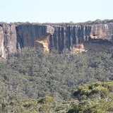
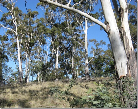
Budawangs–Morton NP in NSW

Image
Foster, Styles Creek, Hidden Valley, Quiltys Circuit 20-23 September 2011 The original intention for this walk was to follow a long used track starting at the Endrick River entrance on the western side of the Budawangs area of Morton National Park. However, this entailed crossing private property and the owner has recently blocked access. So an alternative from the same starting spot was taken, via the Alum Track. It is written up in a guidebook and although part was marked on the map as a route; I assumed that plenty of walkers would have gone this way and a reasonably easy to follow pad, possibly with markers would be there. No sign of a pad existed when we reached the Flat Top Mountain area, so we followed the notes to the top where the view down to Running Creek was enough to cause serious doubts about heading to an area of several creek crossing with unknown scrub. The guide book did mention open sections, but they have either overgrown or we could not locate them; except f

The Hump Freycinet Peninsula

Image
21-23 August 2011 After such a lot of wet easterlies, Freycinet had at last several days of fine weather, which made delaying the walk for a couple of weeks well worthwhile. With so much rain in the area over winter we didn't even bother to see if the preferred route beside the lagoons between Hazards and Wineglass was doable. Instead the conventional slog along the beach was used, then came the pleasure of the bush track from the end of Hazards Beach through masses of flowering plants, especially the Thryptomene which was very thick and spectacular. Given the time it takes to get to the campsite on the spine we had to keep moving and still ended up cooking in the dim of evening. This was the first time trying out our new light weight tent and, as reported by others, one has to erect it with the crossover of the poles given attention; not as simple as some tents. It is a Macpac Macrolight, a bit like a bigger version of the Microlight, and proved to be suitable for a walk to this

Bluff River Gorge

Image
17 August 2011 All did not go according to plan. More often than not the weather improves as you move away from Hobart towards the East coast, but this time it was very much the reverse. We left sunny town and drove into increasingly duller conditions culminating in heavy rain at Buckland. But things got better soon after we turned off on the way to Bluff River Gorge. We arrived to see three walkers heading there too. Soon we too were walking along the 4wd track following their boot marks and along with my trusty GPS meant we were assured of an easy path to the start of the walk. Whilst all in our party queried why I didn't turn off where they thought we should go, I responded by saying the GPS says this way and any way that is where the three fellows boots were headed too. Some 800 metres on I started to have doubts and took a close look at the map on the GPS and the paper map. Heck, we had gone too far. Yes the track was where every one said it was and lesson number one is to r

Risdon Brook Hills

Image
Sunday 24 July 2011 The old vehicle track was followed from the western end of the dam to a junction where the right hand branch was taken leading into an ever narrowing gully. Part way along we branched off on a faint track which did eventually run out but it wasn't a lot of climbing left by then. On the top of the hill a track was met and walked along until it reached the top end of Catchpole Gully. From here we crossed a fence and followed a track along the dry and quite pleasant country, part of which we have discovered is private property. Eventually a fence was reached and fortunately a small tree was over it (looked like it might have been put there rather than fallen) and so we were back in the reserve for the final walk back down to the dam.   A map of the route can be viewed

Panorama Luckman Circuit

Monday 13 June 11 A pleasant walk in calm and sunny conditions. The Luckmans track to the hut was somewhat overgrown and indistinct in parts. This was made harder by snow cover in many spots. The Luckmans Hut was in good condition and after a break we set the GPS for the Wellington Ki Hut ruin where we hoped to locate a geocache and from there crossed the Pinnacle Road on the GPS track again to locate the remains of the Skate Rink, which also has a geocache . From there it was up the road to the top of the Panorama Track to complete a circuit down to the start of the track. The history of these three manmade structures is included. Luckmans Hut This hut does not seem to get many visors although it is clear that some people are using it regularly and also providing some maintenance as some of the timbers don’t seem that old. It has suffered vandalism in the past doesn’t seem to have in the last few years. The Hobart walking Club built this hut 1938 as a winter activity (skiin

Hartz Peak

Thursday 28 April 2011 With a run of very pleasant autumn weather we had a couple of days free for a walk. Initially the thought was to go the Mount Field for the Fagus, but the thought of a horde of people there taking advantage of the public holidays we waited until later in the week and then decided to head in the other direction anyway. Thus it was to Hartz Peak that we went on; the last time there the rock work was only completed on the early part of the climb to the peak, but it was now finished and was a terrific job of work. On the day Lake Esperance was calm and lovely and the views in all direction from the slopes of the peak were stunning and clear.

Mawson Plateau Traverse

Image
Monday 7th March 2011 The track to Lake Belcher was followed to the saddle below Mawson Plateau, then the short climb to the plateau followed by a pleasant walk over the top.  We went to the western side for views over Lakes Belton and Belcher befpre crossing to the opposite side overlooking Lake Dobson.  The descent route was via the ski area and the final descent was via the old and partly overgrowing Golden Stairs. From Lake Dobson we had no choice but to walk up the road to the Wombat Moor car park. View over plateau to Florentine Peak Pool on plateau Grass mound

Pinestone Valley

Image
26 – 29 January 2011 We went in from the end of the Maggs spur road, after lunch, and soon after crossing  the first creek I realised that we shouldn't be going uphill so much.  I had thought the track to Lake McCoy left at the end of a logging track, but  I was mistaken and on retracing my steps discovered that if I had been more observant I would have seen a marker for the track to Pelion going straight ahead.  So that wasted 30 minutes or so before reaching the creek flowing out of the nice valley leading to the foot of Mt Pillinger and our campsite for the night at Wurragarra Creek. Cloud built up over night and it remained that way for the remainder of the day until a light shower started as we got close to the Pinestone valley campsite.   It did not last long and this enabled us to cook and have tea in the open, but a much heavier shower caught us out just as we were finishing our cup of tea.  This was all in accord with the weather forecast, as was the next morning when

Newdegate Pass

Image
Sunday 9 January 2011 With a fine forecast we set off from Lake Dobson, took the Urquhart Track and then endured the Jeep 4WD road to the ski huts. From here it became pleasant walking again and we decided to head to Newdegate via Tarn Shelf, joined the new boardwalk from Lake Newdegate and spent an enjoyable lunch break amongst the white flowering Cushion Plants, Epacris and colourful Scoparia. Return was via K Col and the climb over the rocks to the Rodway Range. For a change we located the old Golden Stairs to see what that track now looked like. Parts were a bit overgrown but nonetheless it was not difficult to follow until the very bottom. Quite a number of people did the Newdegate Pass circuit that day and most chose to go the opposite way to us; over the Rodways first. Sue did mention that I was the oldest person out on the track and that gave me an uneasy feeling; it is always nice to know that someone else is the oldest and not you. Cushion Plant Newdegate Pass Scoparia