Cheyne Range 2019
21-24 October 2019
This was a walk I did in 2004 and didn't really imagine that I would be repeating it.
Apart from the climb over the rocks below Little Hugel things were going OK. The supposed best way down to Lake Hermione was taken, but it proved to be far from ideal and those that had used different routes on previous occasions felt they were easier. There were lots of fallen trees to get over and plenty of scrub.
The Franklin River below Hermione, where we crossed, was running high and we got wet almost to the hips. Camp was made at the lake and we sat out in the pleasant sun.
Heavy frost heralded a nice day for the walk through the lovely valleys of the Cheyne Range. It featured pencil pine forests, tarns, lakes and no scrub. It was a bit of a grunt for the ascent to the top of the range, but it was the descent towards the lake that was to be our campsite that took its toll. We reached a thick scrubby section and found there was no way round so had to force a way through. When the valley was reached the decision was to make camp.
Next morning in still good weather there was only a short band of myrtle forest before open ground leading steadily up the 4.5K to Mount Gell. The descent to Lake Australia was a bit more time consuming than expected as the pad which we had picked up could no longer be found and resulted in us spending time in the scrub getting around a cliff.
We knew the last day would be long, but part way down from The Hippogriff a cliff was reached and it was either back up or continue down to find the best way. It didn’t take long to realise that down had not been the best option, because once down the cliff another was met soon after then another and so on. Probably eight cliffs were met, and each was time consuming locating a way off them. Once the final one was over with the scrub became very thick and it was a relief to all when the Franklin River was met. This put us 400 metres above the intended crossing, but fortunately the riverbank provided reasonably quick travel.
Once over and wet only up to the thighs the long trudge to the Rufus Canal Road began, some 6.3k away. We arrived 5 hours later with day taking 11 hours. I was extremely tired and felt exhausted; it was far too long for me nowadays.

Cheyne 2019
The album can be viewed as slide show and it also allows music to be turned on.

This was a walk I did in 2004 and didn't really imagine that I would be repeating it.
Apart from the climb over the rocks below Little Hugel things were going OK. The supposed best way down to Lake Hermione was taken, but it proved to be far from ideal and those that had used different routes on previous occasions felt they were easier. There were lots of fallen trees to get over and plenty of scrub.
 |
| Ssnow capped peaks |
 |
| Tents at Lake Hermoine |
The Franklin River below Hermione, where we crossed, was running high and we got wet almost to the hips. Camp was made at the lake and we sat out in the pleasant sun.
 |
| Lake Hermione in morning day 2 |
 |
| Tarn Cheyne Range |
 |
| Pencil pines Cheyne Range |
Heavy frost heralded a nice day for the walk through the lovely valleys of the Cheyne Range. It featured pencil pine forests, tarns, lakes and no scrub. It was a bit of a grunt for the ascent to the top of the range, but it was the descent towards the lake that was to be our campsite that took its toll. We reached a thick scrubby section and found there was no way round so had to force a way through. When the valley was reached the decision was to make camp.
 |
| Tents in valley Cheyne Range |
 |
| Mount Rufus and pines towards sunset |
 |
| Mount Gell ahead |
 |
| Lake Australia and Mount Gell |
We knew the last day would be long, but part way down from The Hippogriff a cliff was reached and it was either back up or continue down to find the best way. It didn’t take long to realise that down had not been the best option, because once down the cliff another was met soon after then another and so on. Probably eight cliffs were met, and each was time consuming locating a way off them. Once the final one was over with the scrub became very thick and it was a relief to all when the Franklin River was met. This put us 400 metres above the intended crossing, but fortunately the riverbank provided reasonably quick travel.
 |
| Lake Australia and Mount Gell from The Hippogriff |
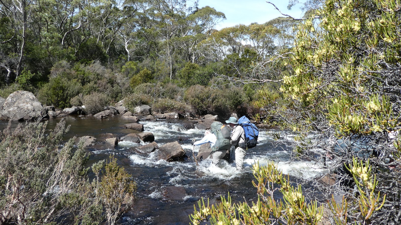 |
| Crosing the Franklin River |
Click on the image below for a photo album
Cheyne 2019
The album can be viewed as slide show and it also allows music to be turned on.
Hi
ReplyDeleteCan you tell me how many days/hours per day this took you? Even better do you have a route map or GPS. It looks like a beautiful walk. Well done!