Mt Crooke
Most of this walk was off track and included negotiating a bit of scrub, including Scoparia, and a fair bit of uneven terrain underfoot.
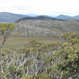
Initially the track to Mt Field East was followed and I was able to point out the work done by the Friends of Mt Field on hardening the track . On the highest part of the saddle at the top of the climb and before windy Moor we turned northwest and walked through a lovely area of bushes with open space between them that made walking easy. A gentle climb brought us to an unnamed rocky knoll that was actually higher than nearby named features including Mt Crooke, our walk destination. The descent brought the first unavoidable scrub, including some Scoparia in flower. Beyond this we entered the valley holding the headwaters of the Davis River and then began the 45 minute and 900 metre walk through the scrub for an ascent of a mere 100 metres to the summit of Mt Crooke.
A slightly different return path was used, but we still encountered some Scoparia; just enough to make us look closely to find the thinnest patches through. Once back in the valley of the Davis we walked up the watershed and then descended to the Lake Fenton to Webster track.
The day was sunny and mild with a gentle cooling breeze, the wildflowers were good and we obtained unique views to Lakes Webster and Seal and had the vista across the valley of the distinct line of the Tarn Shelf. It took 2:25 of walking to get to Mt Crooke and 2:15 to get back.
---------------
 |
| Mt Crooke 11 |
Comments
Post a Comment