An Attempt on Mt Jukes

Wednesday 14 November 2007
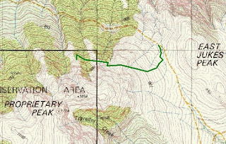
We located an old bulldozer track uphill from the lookout and eventually came onto a cut track with plastic markers and occasional wooden posts. The track contoured the slope crossing small gullies, but at 828309 it ceased and we could not locate an extension anywhere.
We both wondered why the cut track should be heading in the direction it did as we thought it more logical to ascend more directly to Proprietary Peak. Although conditional were quite cloudy when we started by the time we reached the end of the cut track it was quite drizzly and visibility poor with the peaks now completely blanketed, so we decided it best to retreat and return when conditions were better
On the 24-11-07 I climbed Mt Juke via the old track from near Lake Burbury. As shown on 1:100,000 Map Franklin. It was difficult to locate the start as it is now on the top of a road cutting. There is a little cairn at the bottom and blue tape at the top. The track goes near the old power poles (cut off) and then follow a trench up the hill until merging onto an old pack horse road or tramway. Most sections are pretty clear, but there are a couple sections with lots of trees over. After about 1 hour you reach the second creek where the track splits, left heads up towards pyramid peak, then an overgrown section leads to the left to overlook Lower Lake Jukes. Track disappears. I went back to the previous juntion.
ReplyDeleteThe straight ahead direction of the branch follows the ridgeline up. The markers lead towards the old Lake Jukes Mines, while I continued up the ridge, to the cliffs at the edge of the Cirque before climbing a buttress and vegetated gully to the Plateau. Visibility was very poor, less than 10m due to cloud, but I was able to locate the trig point but no views. There were a couple cairns but I didn't notice a defined track before I return the way I came up. My total trip was 7 hours, the upper sections had no tracks, the rest not many markers.