Posts

Showing posts from September, 2022

Lower Slopes Circuit

Image
 26 September 2022 Whilst walking along O.Gradys Falls Track we passed a log with sign on side, must have been past it many times but never noticed it. Took photo and phone did translation detecting it was Lithuanian. How nifty is that.   The sign Translated on the spot  

Johnstons Knob

Image
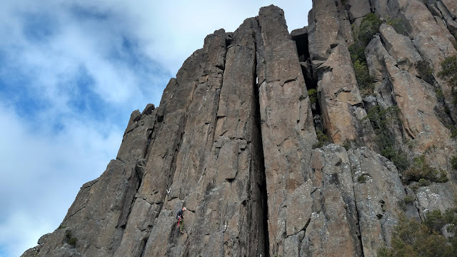
  Tuesday 20 September This walk followed the climbers track to be base of the Organ Pipes then continued north on scrubby but mostly obvious pad along the base to a buttress known to rock climbers as Far North and just beyond the spire known as Johnstons Knob was reached. Historical records mention Johnstons Lookout was discovered by the family of council clerk A. W. (Cecil) Johnston.     But the 1935 Hodgman map shows a Johnstons Lookout on the Organ Pipes Track, so this probably not the Knob.     On the other hand, Ron Smith's 1941 shows a Haywoods Peak at about the spot of Johnsons Knob. Back to the walk, and from the bottom of the buttress a pad leading up a steep and at times up and over boulders.    When last here in 2014 a ladder had been installed to help get up on a ledge, but even so it was still tricky to get up.   After a couple more encounters with rock faces we were out in the open above the Organ Pipes.   After lunch a circuitous route was followed to the sum

Redgate Hills and Cliffs

Image
Tuesday 13 September 2022 Redgate is the name applied to the Parks & Wildlife eastern section of the Meehan Range. A couple of years ago I noticed, from a distance, what appears to be some small cliffs on the south side of the gully, now known as Air Force Gully replacing Stringy Bark in 2019. The aim of the walk was to see if on closer inspection there are cliffs at the spot or just sloping bare earth. According to the geological map the area is siltstone with thin beds of sandstone. It was a sunny and pleasant day, and by the time we arrived at search location, quite warm.   There were cliffs and a few caves, one of \which was big enough to enter.  We continued along the base of them for 560m and that took about 40 minutes.   Lunch was on top and then started the return walk via the higher cliffs on the opposite side of the ridge, before heading back to the cars. Large Eucalypt Simmons Hill   Redgate cliifs Cave Cliifs  Click on the photo below for an album     Redgate Cliffs

Fairy Falls & Featherstone Cascades

Image
Thursday 25 August 2022 This was a walk to see a couple of rarely visited waterfalls on the lower slopes of the mountain.  The first one being Fairy Falls, an unofficial name, which is reached from a pad branching off the Lower Sawmill Track. It is quite reasonable going, initially uphill for about half the distance before contouring to the waterfall.    Quite a nice little fall. Fairy Falls   The next one is Featherstone Cascades which is on a track that starts from the Betts Vale Track soon after O’Gradys Falls.   Evidently it was a quite popular destination in the early days of Hobart with a substantial zigzag track, parts of which are still visible. Most of the way was distinct although a couple of times we had to negotiate fallen trees.   The remainder of the walk was up Betts Vale Track and down Lower Sawmill to the cars at Strickland Avenue Featherstone Cascades   Note the old track zig zagging up beside Featherstone Cascades     There is a photo album