Cliffs But No Flora
Floras Falls Expedition Number Two
Wednesday 24 January 2018
After the attempt to find Floras Falls in November I had put
the falls way off in the back of my mind, thinking that was probably it. However, Adrian gave some more thought then worked
out another possible location.
 |
| Yellow Cliffs from Glen Dhu cliffs |
A warm day was predicted, but the morning was really a most
pleasant temperature. After an hour we departed the track through bush burnt
in the Molesworth fire of February 2013.
We had walked about 300 metres into the bush and were quite surprised
to come upon a hut ruin. The outline was obvious and the rocks making up the chimney
end were standing to shoulder height and one part at head height. A sandstone hearth was intact and apparently in
good order. Scattered bits of tin and a water tank lay nearby. Another surprise was a beer can that had been
placed on a branch and a yellow tape tied to a tree, indicating a quite recent
visitor.
 |
| Old hut site |
From here it was another 250 metres to a lookout to part of
the Yellow Cliffs making it an inviting place to stop for refreshments.
The creek where it was hoped to find Floras Falls was not far away and being unburnt was a bit scrubby initially. The creek was small but had a decent flow, and following some investigating we not unexpectedly concluded that the falls were not at this site.
 |
| Yellow Cliffs from southern lookout (morning tea break) |
The creek where it was hoped to find Floras Falls was not far away and being unburnt was a bit scrubby initially. The creek was small but had a decent flow, and following some investigating we not unexpectedly concluded that the falls were not at this site.
On leaving the creek a direct line was taken to the main
cliff edge some 250 metres away, passing a spot where several large eucalypts
had been sawn down and mostly left. We
were all quite mystified by this as it was almost 500 metres to the closest point on Glen Dhu Fire Trail, which has been impassable to vehicles for about 15
years, there was no sign of a loggers track and at a guess the trees had been
cut down between 10 and 20 years ago.
 |
| Yellow Cliffs from lookout |
 |
| On first ledge below the top |
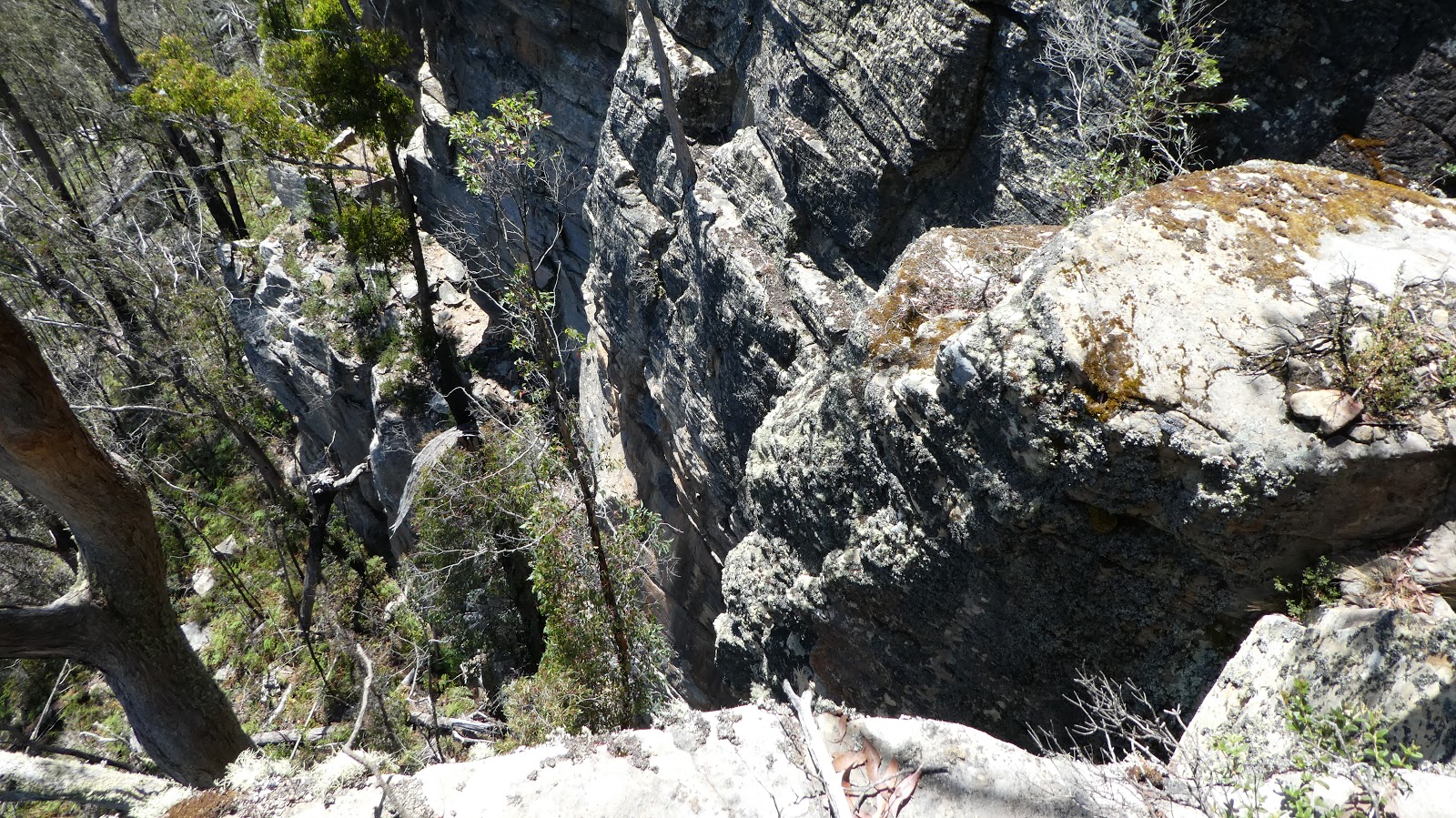 |
| Looking down Glen Dhu Cliffs |
The cliffs were splendid with as good a view as you’re likely
to get of the yellow Cliffs; they looked close but were 500 metres off. From where we were perched it was a spectacular
sheer drop. Fortunately, it was lunch
time and the temperature on the cliffs ideal for sitting back gazing at the view.
By the time the track was reached it was warming up but for
most of the journey out, there was plenty of tree shade.

Glen Dhu Cliffs
A photo album is online click here or on the image below
Glen Dhu Cliffs
 |
| Route from old Glen Dhu Trail |
Some background from the records of the journey made to Floras Falls in
1894
The
written information (The Mercury Supplement, Saturday 24 Nov 1894) indicates
that the walk started at a house in the Collins Cap area and they "went to
see some wonderful falls under the peak of the cap".
The walk
started at "Blumberg" (hill of flowers), the residence of Mr. R.
Relet. This was described as being over 10 miles (16 km) from the nearest
railway station. Presumably travel was by horse (buggy) or walking on existing
roads, described as "excellent". By modern roads from near Collins
Cap to Berriedale is about 14 km. Thus the house might be situated near
Nicholls Road (or the end of Glen Dhu Road).
They went
up a ridge and then descended its very steep side, getting to a platform
"on top of the 1 west of three falls". l west - meaning? lowest? (The
ridge could be something like the one bearing the Glen Dhu Trail that probably
did not exist then.)
Eventually
they got to the bottom of the lowest and biggest falls.
At this
point:
They were in the heel of a horseshoe amphitheatre of uniform
perpendicular rocks (sandstone from photos).
The lower portions of the bare walls encompassed them on three sides.
The upper portions were "indented here and there, with delightful
caves".
When "facing the fall, the right o'er-shadowed (but not
discernible) by the waratah, clematis, and grass-tree, crowned majestic
Collins' Cap". (In modern terms "grass-tree" is not Xanthorrhoea
sp. but man fern?)
Presumably this last statement means that when at the base of the falls,
Collins Cap is on the right hand side of the falls (although not visible). That
seems to not fit with a Yellow Cliffs location; anywhere there Collins Cap
would be to the left and relatively a long way away.
There are
said to be three falls:
"Flora's lower and grandest fall" possibly 200ft (60 m) in
height.
Middle falls "Something under 50ft (15 m) in height" and
"very much resembles the Silver Falls on Mount Wellington, but surpasses
it in beauty".
Upper falls "the topmost and smallest, but very pretty, fall of the
three".
Hi Peter,
ReplyDeleteI can now confirm that Floras Falls are what today's maps call Silver Falls, about 2 km NNW of Collins Cap summit. They are worth a visit, and not that far off the road.
SILVER (FLORAS) FALLS
Drive 400m along Nicholls Road, turn right and travel 300m along Stocks Rd, and park. (GR 510900 5256690) The land north of the road is classified as Public Reserve.
From the car, go directly down the steep rounded spur through dry rocky bush for 200m to Silver Falls Creek. If in doubt, trend right (east) so as to reach the creek upstream of the falls. Turn left and follow the stream bed downstream until you abruptly reach the top of Silver Falls. (GR 510845 5256890) The base of the falls can be reached by skirting right (north) for 100m and then descending the bushy slopes to the base of the amphitheatre. (The southern flank is broken, rocky, and less safe).
The main Silver Falls are about 70m high, dropping in two overhanging tiers with a steep cascade in between. The rock is horizontally-bedded mudstone. The catchment above the falls is small, so water flows in summer are less than impressive. It is possible to (carefully) go behind the water spray under each overhang. The falls were obviously known to locals in the 19th Century, and they guided Charles Ramsay there as recorded in his florid article in the Mercury on Sat 24th November 1994. Ramsay “named” them Floras Falls, and that name must have lasted for at least 11 years, as evidenced in the Weekly Courier on August 12th and September 16th 1905, which printed photos by Beattie that were captioned as Floras Falls.
Enjoy!
Martin Stone
Thanks very much for the information, Martin.
DeleteOddly enough I had some locations in my GPS to visit Silver Falls and planned to go there
when we got back, but our enthusiasm was not sufficient for us to go that day. We had it in mind to go there another day and now with your information we certainly will before long.
I used to live at the property where silver falls is it is a 10min walk from 647 Collinscap Rd Collins cap this was my old farm growing up as a kid. take the track besides house get permission 1st it's your second right walking down then 1st right up the hill right next to the burned down hut about 50m up the hill U will see a track going left follow till U hear the falls .track is new old one burned out but only 5 min walk from the burned hut
Delete